- - - snip - - -
How Much Would A Doubling Of CO2 Affect The Radiative Transfer Balance?
According to RRTM (the model used by NCAR) – if CO2 increases to 550 PPM in the tropics, the amount of downwelling longwave radiation would only increase by 0.6 watts/metre, or less than 0.2%
In other words, man made CO2 has almost no impact on the climate of the tropics. People who claim CO2 increases hurricanes have no idea what they are talking about.

Arctic scientists are watching in awe this week as a raging summer cyclone tears up what could become a record amount of rotting northern sea ice.
"We're really watching this year with a lot of fascination," said Matthew Asplin, an Arctic climatologist at the University of Manitoba.
Arctic cyclones are driven by low-pressure systems in which winds of up to 100 km/h blow counter-clockwise in spiral more than 1,000 kilometres across. They occur in both winter and summer, but are usually stronger in winter.
Cyclones are not unusual in the Arctic, but seem to be changing in recent years, said David Barber, one of Canada's top sea-ice experts.
"These cyclones are not getting more frequent, but they are getting deeper -- which means stronger," he said.


And they're getting harder on sea ice, which they break up through wave action associated with high winds and through rainfall, which darkens the ice and makes it absorb more solar energy. The storms also bring up water from the depths, which is actually warmer than surface water.
Cyclones can destroy large amounts of ice very quickly.
"In 2009, we actually documented one of these events in which large, multi-year ice floes -- Manhattan-sized -- broke up in a matter of minutes," said Barber.
Last year, a particularly powerful cyclone is thought to have wiped out 800,000 square kilometres of ice. That contributed to record low sea-ice levels at the end of the 2012 melt year.
This year's storm over the Beaufort Sea formed about mid-week and is expected to die out on the weekend.
It isn't as strong as last year's, but the ice is thinner and weaker. As well, the ice has already been pummelled by earlier storms.
"The effects of (the storm) are nowhere near what we saw last August," said Asplin. "But because the ice is thinner and it's already been pre-conditioned, and because there's less volume, it's much more vulnerable to impacts from this sort of thing."
Barber said the ice is getting so weak that new categories have had to be created for it.
"We have a whole new class of sea ice in the Arctic, which we're calling 'decayed ice,"' he said.
"We started seeing it in 2009. It's extremely weak."
Barber said the research icebreaker CCGS Amundsen can do 13.5 knots in open water. Through decayed ice, it can do 13 knots.
Changing sea-ice cover is increasingly being linked to southern weather patterns. The jet stream, which strongly influences weather at mid-latitudes, is driven by temperature differences between the Arctic and the equator, a difference that shrinks with the sea ice.
Ice coverage is slightly about last year's record low but still well below the 30-year average.
Much remains unknown about the role of Arctic cyclones in the annual freeze-thaw cycle. Back when the sea was thick and lasted for years, cyclones tended to spread the ice out and actually increase its extent, said Julienne Stroeve of the National Snow and Ice Data Center in Boulder, Colo. Now, when ice gets spread out, it simply breaks up and disappears.
"As our ice cover has thinned, some of our old rules are changing," said Stroeve.
Asplin said cyclones will be a big part of the research agenda when the Amundsen sets sail for the Arctic again later this month.
"This year has been very stormy. The month of August is definitely one to watch in the Arctic."
http://www2.macleans.ca/2013/07/25/scientists-watch-arctic-cyclone-chew-up-sea-ice/
ARCTIC STORM IN 2012
http://thewatchers.adorraeli.com/wp-content/uploads/2012/08/01676923b6a7970b.gif
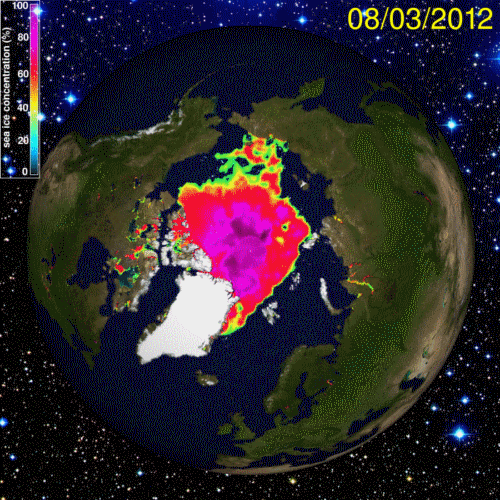
[1] On 2 August 2012 a dramatic storm formed over Siberia, moved into the Arctic, and died in the Canadian Arctic Archipelago on 14 August. During its lifetime its central pressure dropped to 966 hPa, leading it to be dubbed ‘The Great Arctic Cyclone of August 2012’. This cyclone occurred during a period when the sea ice extent was on the way to reaching a new satellite-era low, and its intense behavior was related to baroclinicity and a tropopause polar vortex. The pressure of the storm was the lowest of all Arctic August storms over our record starting in 1979, and the system was also the most extreme when a combination of key cyclone properties was considered. Even though, climatologically, summer is a ‘quiet’ time in the Arctic, when compared withall Arctic storms across the period it came in as the 13th most extreme storm, warranting the attribution of ‘Great’.
http://onlinelibrary.wiley.com/doi/10.1029/2012GL054259/abstract
Arctic Cyclone Of August 2012 Is Not Responsible For Record Sea Ice Melt, Study Says
The scene of the crime: The Arctic.
The suspect: The Great Arctic Cyclone of August 2012.
The victim: The Arctic sea ice, which melted to a record low area last year.
"The Great Arctic Cyclone of August 2012" arose in Siberia on Aug. 2 and crossed the Arctic Ocean to Canada, lasting an unusually long 13 days. The cyclone hit a pressure minimum of 966 millibars on Aug. 6, the lowest ever recorded for an Arctic storm. The stronger the pressure gradient, or difference in pressure, the stronger the winds associated with a storm.
Since the storm, which was equal in strength to a hurricane, tore across the Arctic, scientists have wondered whether its winds and waves were a guilty party in the disappearing Arctic sea ice.
Guilty or not guilty?
To solve the mystery, climate scientists from the University of Washington performed the equivalent of a forensic exam: They ran a computer simulation of last summer's weather and compared it against a second scenario that was identical, except that there was no cyclone.
"The storm was enormous," study co-author Axel Schweiger, a polar scientist in the university's Applied Physics Laboratory, said in a statement. "The impact on the ice was immediately obvious, but the question was whether the ice that went away during the storm would have melted anyway because it was thin to begin with."
Though the storm had a huge impact on sea ice while it passed, within two weeks, the effect diminished, lead author Jinlun Zhang, also a scientist in the university's Applied Physics Laboratory, said in the statement.
The final verdict? Not guilty
The scientists conclude the cyclone reduced the final September ice extent by almost 60,000 square miles (150,000 square kilometers), an additional 5 percent. However, they point out that 2012's record loss was 18 percent greater than the previous low, set in 2007. [Video: Powerful Arctic Cyclone Wreaks Havoc on Sea Ice]
"Thus without the storm, 2012 would still have produced a record minimum," the authors report in their study, which appears online this week in the journal Geophysical Research Letters.
Warmed from below
The research also revealed an unusual mechanism for the cyclone-related melting. A study published Dec. 15, 2012, in the same journal focused on winds breaking up the ice or driving ice floes into areas of warmer water.
But the University of Washington team found that during the storm, the ice melted largely from warm ocean water churned up by the passing storm. Melting quadrupled during the storm, and the rate of ice loss doubled, the study found.
In the Arctic summer, ocean water becomes stratified from melting ice, according to a statement from the university. A layer of ice-cold fresh watersits just beneath the sea ice. But about 65 feet (20 meters) below the surface, there is a layer of denser, saltier water that has been gradually warmed by the sun's rays.
When the cyclone swept over the drifting ice floes, underside ridges churned up the water, bringing sun-warmed seawater to the ice's bottom edge and causing it to melt, the study suggests.
Reach Becky Oskin at boskin@techmedianetwork.com. Follow her on Twitter@beckyoskin. Follow OurAmazingPlanet on Twitter @OAPlanet. We're also on Facebook and Google+.
- 10 Things You Need to Know About Arctic Sea Ice
- On Ice: Stunning Images of Canadian Arctic
- Weirdo Weather: 7 Rare Weather Events
Copyright 2013 OurAmazingPlanet, a TechMediaNetwork company. All rights reserved. This material may not be published, broadcast, rewritten or redistributed.
http://stevengoddard.wordpress.com/2013/08/04/sea-level-used-to-be-ten-feet-higher-and-the-arctic-was-ice-free/
http://stevengoddard.wordpress.com/2013/08/04/sea-level-used-to-be-ten-feet-higher-and-the-arctic-was-ice-free/
Sea Level Used To Be Ten Feet Higher And The Arctic Was Ice Free
A reminder that there was a time when scientists actually did science.
Santa Cruz, California Sea Level Drops To Its Lowest Level In The Satellite Era
Last year, Heidi’s geniuses predicted that California sea level would rise at least six inches by 2030.
April 20, 2012In the 20th century, the sea level rose on average 8 inches along California’s coastline, research by Climate Central and others shows.Middle-of-the-road expectations are that it will rise 6 to 8 more inches by 2030, 12 inches by 2050 and 24 inches by 2070.By 2100, it could be 3 to 5 feet higher, said Gary Griggs, director of the Institute of Marine Sciences at UC Santa Cruz.
Since these expert forecasts were made, University of Colorado satellite data shows sea level at Santa Cruz dropping to its lowest level on record.
No comments:
Post a Comment
Enter your comment(s) here...